Looking for a map of Nicaragua? Our guide will escort you through the country’s distinct regions: the volcanic Pacific Lowlands, the serene North Central Highlands, and the lush Caribbean Lowlands. We’ll also pinpoint key cities and landmarks worth noting on any map. This article provides an essential overview for travelers, students, or anyone interested in the geographic tapestry that defines Nicaragua.
Table of Contents
Key Takeaways
Nicaragua, known as the ‘Land of Lakes and Volcanoes,’ features diverse geographic regions including the agriculturally rich Pacific Lowlands, the rugged North Central Highlands, and the ecologically diverse Caribbean Lowlands.
Major cities such as Managua, León, and Granada are pivotal to Nicaragua’s urban charm, cultural diversity, and economic activity, while its natural landscapes offer a range of activities from hiking to watersports.
Nicaragua’s rich history, cultural diversity, and natural beauty make it an attractive destination for tourism, offering historical architecture, ecotourism, and adventure sports amidst its 15 departments and two autonomous regions.
Discovering Nicaragua: Geography and Regions
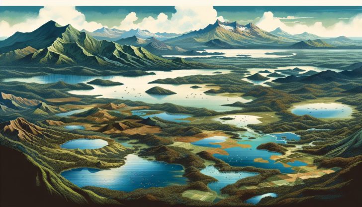
Nicaragua, the largest country in Central America, is a land of splendid diversity. This ‘Land of Lakes and Volcanoes,’ as it’s often called, is blessed with an array of landscapes from lakes, lagoons, rivers, coastal plains, to interior mountains. The country’s land use is broadly divided into agricultural (42.2%), forests (25.3%), and other uses (32.5%).
The geographical beauty of Nicaragua is further enhanced by an impressive chain of 19 active volcanoes, part of the Central America Volcanic Arc. These natural formations divide the country into three distinct regions: the Pacific Lowlands, North Central Highlands, and Caribbean Lowlands, each with unique topographical and ecological characteristics.
Pacific Lowlands
Situated along the western edge of the country, the Pacific Lowlands present a region of striking uniformity and beauty. They boast:
Virtually constant temperatures, typically ranging between 85 to 90 °F
A predominantly dry climate from November to April, offering a pleasant escape for those seeking a respite from colder climates
A landscape molded by a chain of partially active volcanoes, which provides a unique character to this region.
These volcanic formations, part of the Central America Volcanic Arc, don’t just add to the aesthetic appeal of the Pacific Lowlands but have also shaped its ecological landscapes. The volcanic soil is rich and fertile, supporting a variety of flora and fauna, and contributing to the region’s biodiversity. This ecological richness, combined with the region’s captivating beauty, offers a unique natural canvas that is both enriching and awe-inspiring.
Furthermore, the Pacific Lowlands provide a haven for adventure enthusiasts. The volcanic peaks challenge climbers with their towering heights, while the vast Pacific Ocean provides a playground for water sports enthusiasts. Over the years, this region has developed into a significant tourism hotspot, attracting visitors with its unique blend of natural beauty and adventure.
North Central Highlands
In stark contrast to the Pacific Lowlands, the North Central Highlands of Nicaragua are characterized by:
Rugged mountains
Extensive coffee plantations
Cooler temperatures due to the altitude
More rainfall compared to other regions
Fertile soil, creating excellent conditions for agriculture.
These highlands are home to a variety of crops such as:
coffee
cattle
milk products
vegetables
wood
gold
flowers
sugarcane
rice
oil palm fruit
maize
plantains
cassava
groundnuts
beans
The landscape is a patchwork of lush green fields, vibrant flower beds, and dense forests, offering a picturesque spectacle that is a delight for the senses.
Beyond agriculture, the North Central Highlands also… The unique geographical features and the richness of the local culture provide a strong foundation for ecotourism. While the specifics are not detailed in the source facts, the potential for nature walks, wildlife spotting, and cultural interaction can be inferred.
This region, with its natural beauty and agricultural abundance, presents a unique facet of Nicaraguan life.
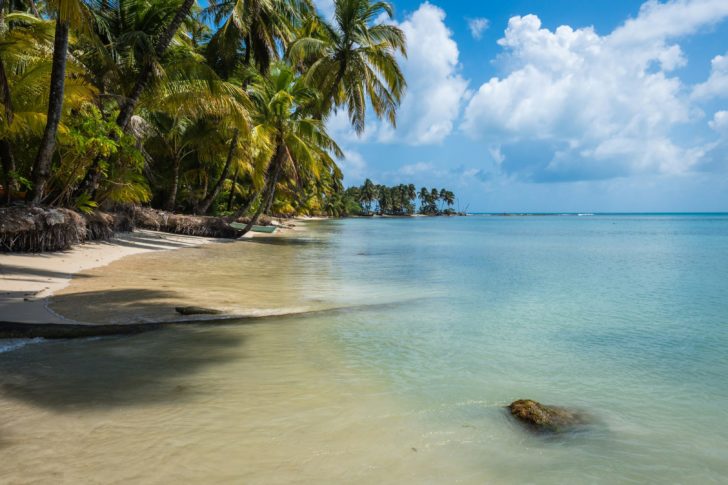
Caribbean Lowlands
The Caribbean Lowlands, constituting the eastern half of Nicaragua, provide a unique experience of their own. Characterized by a humid tropical climate, this region is marked by extensive rainforests, rivers, and swamp lands. The region’s ecological richness is unmatched, with the dense forests home to a variety of plant and animal species.
One of the defining features of the Caribbean Lowlands is the Rio Coco, the largest river in Central America. This river forms the border with Honduras and is a vital geographical feature of the region. The river, with its winding course and lush green banks, adds a unique charm to the Caribbean Lowlands.
Despite the challenging geographical conditions, the Caribbean Lowlands reveal a different aspect of Nicaragua’s biodiversity. The dense forests, the wide rivers, and the swampy marshlands are a testament to nature’s resilience and diversity. This region, with its untamed wilderness and natural beauty, offers a unique perspective on Nicaragua’s ecological riches.
Navigating Nicaragua: Major Cities and Transportation
Transitioning from the diverse geographical landscapes, we delve into the urban tapestry of Nicaragua. The national capital, Managua, is not only the capital city but also the largest city of the country. The urban charm of Nicaragua extends beyond Managua, with other significant cities like León, Masaya, and Granada each offering unique cultural and architectural treasures.
Historical rivalries, particularly between Liberal León and Conservative Granada, have shaped the political and cultural landscape of Nicaragua’s major cities. These cities, with their historical significance and cultural richness, offer a unique glimpse into the country’s past and present. From the architectural grandeur of colonial-era buildings to the bustling city streets teeming with local markets, these cities are a microcosm of Nicaraguan life.
Interestingly, the populations of Nicaraguan departments are primarily concentrated in the western half of the country, with significant urbanization and population clusters in Managua. These urban areas are not just residential hubs but also centers of economic activity. From Estelí’s renowned tobacco production to various manufacturing sectors throughout the western region, these cities are the economic lifeline of Nicaragua.
The Beauty of Nicaragua’s Natural Landscapes
The beauty of Nicaragua is not limited to its urban landscape. The country’s natural landscapes are equally enchanting. The country is home to Central America’s largest freshwater lakes, Lake Managua and Lake Nicaragua. These lakes, situated in the Pacific Lowlands, offer activities like visiting volcanic islands and the Ometepe Island Biosphere Reserve.
Another impressive natural landmark is the Mogotón Peak, the highest peak in Nicaragua. Standing at 2,103 meters (6,900 ft), it poses as both a natural landmark and a pinnacle for those seeking nature’s grandeur. The peak, with its towering height and commanding view, is a testament to the country’s diverse topography.
Ranging from tranquil lakes to towering peaks, these natural landscapes infuse a distinctive charm into Nicaragua. They offer a serene escape from the urban hustle, providing a haven for nature lovers. The beauty of these landscapes is a testament to the country’s ecological richness and geographical diversity.
Understanding Nicaragua’s Climate
The climate of Nicaragua is closely intertwined with its geographical diversity. The country experiences a tropical climate, with average temperatures typically ranging from 21°C to 27°C. This warm tropical weather, consistent throughout the year, offers a comfortable environment for both locals and tourists.
The tropical climate is characterized by a wet season from May to October and a dry season from November to April. During the wet season, there is usually a brief dry spell known as the ‘Canícula’ around late July to early August. This seasonal variation adds another layer of diversity to the country’s climate.
However, it’s important to note that climate conditions can vary significantly due to the El Niño Southern Oscillation, leading to periods of warmer and drier or colder and wetter weather. From July to October, Nicaragua endures increased rainfall and stronger winds, a part of its active hurricane season involving Pacific cyclones and Atlantic hurricanes.
Interestingly, the eastern slopes of Nicaragua’s central highlands are among the wettest areas on Earth, indicating significant regional climate variation within the country.
Historical Overview: From Pre-Columbian Times to Present Day
Nicaragua’s rich tapestry is woven with threads of a vibrant past. The country’s history spans from pre-Columbian times, when indigenous tribes inhabited the region, to the present day. The key events in Nicaragua’s history include:
The Spanish colonization, which began in 1519 under the leadership of Pedro Arias Dávila and Gil González Dávila
The fight for independence from Spain in the early 19th century
The U.S. military intervention in the early 20th century
The Sandinista Revolution in the late 20th century
These events have shaped the country and its people, and understanding Nicaragua’s history is key to understanding its culture and society today.
The indigenous population in Nicaragua’s Pacific region saw a dramatic decline within three decades following the Spanish conquest, largely due to diseases and enslavement. During the colonial era, Granada and León emerged as significant centers of power, with Granada focusing on agriculture and trade and León on commerce with other Pacific colonies.
The struggle for sovereignty marked a milestone in 1821 when Nicaragua declared independence from Spain. A period of relative peace ensued between 1857 and 1893 under Conservative rule, with the establishment of Managua as the capital city. This was chosen as a compromise between the rival cities of Granada and León, symbolizing the ongoing effort to unify the country’s diverse political and cultural landscape.
Cultural Diversity: People, Languages, and Religions
Nicaragua’s vibrant cultural landscape encapsulates its past and present. The majority of Nicaraguans are Mestizos, descendants of indigenous peoples and Spanish colonizers. White Nicaraguans, mostly descendants of Spanish immigrants, form another significant ethnic group. Indigenous ethnic groups, such as:
Nahua
Sutiaba
Mayangna
Matagalpa
Chorotega
Rama
Indigenous communities in some of the poorest countries make up about 5% of the country and are the primary group maintaining indigenous languages and customs.
Language plays a key role in preserving and showcasing cultural diversity. While Spanish is the official language spoken by the majority, indigenous languages, English-based creoles, and other languages are spoken on the Caribbean coast. This linguistic diversity adds another layer of richness to the cultural fabric of Nicaragua.
Religion is another aspect where diversity is evident. Nicaragua has traditionally had a majority of Roman Catholics, making it the largest denomination in the country. This indicates the significant influence of Roman Catholicism within Nicaragua. Religious festivals and reverence for local saints play a significant role in cultural identity.
This blend of ethnic, linguistic, and religious diversity forms the essence of Nicaragua’s vibrant culture.
Tourism Hotspots: Must-See Destinations
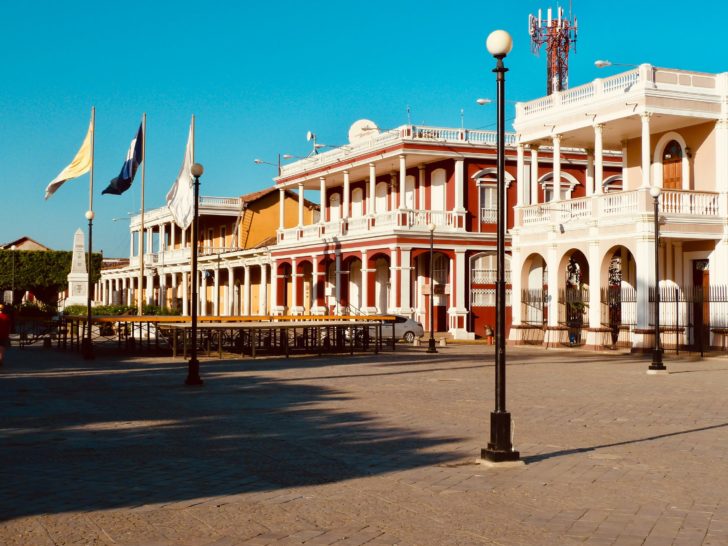
Boasting geographical and cultural richness, Nicaragua is a paradise for tourists. The country boasts a range of attractions, from historical cities to natural landscapes. The colonial cities of León and Granada are celebrated for their historical architecture and cultural riches.
The Corn Islands and other picturesque maritime locations, including the Mosquito Coast, offer a tranquil Caribbean atmosphere with opportunities for diving and connecting with friendly locals. For those seeking a deeper connection with nature, ecotourism sites like Morgan’s Rock Ecolodge and cultural agritourism experiences in the White Villages provide unique experiences.
For adventure enthusiasts, the Pacific coast hosts some of the most sought-after surf beaches, including San Juan del Sur and El Ostional, attracting surf enthusiasts from around the world. Whether you’re a history buff, nature lover, or thrill-seeker, Nicaragua has something to offer to every traveler.
The Nicaraguan Flag and National Symbols
Nicaragua’s national symbols eloquently express the rich tapestry of its cultural and geographical diversity. The Nicaraguan flag features three horizontal bands. The blue upper and bottom bands represent the Pacific Ocean and Caribbean Sea, while the white middle band symbolizes purity. At the center lies the national coat of arms.
The coat of arms of Nicaragua includes:
A representation of nature within a triangle, symbolizing the country’s ecological richness and diversity
The words ‘REPUBLICA DE NICARAGUA’ located at the top
‘AMERICA CENTRAL’ placed at the bottom
The national anthem of Nicaragua, titled ‘Salve a ti, Nicaragua’ (Hail to Thee, Nicaragua), was officially adopted in 1971, adding another layer to the country’s national identity.
Administrative Divisions: Departments and Autonomous Regions
The diversity of Nicaragua is also reflected in its administrative divisions. The country is comprised of 15 departments, each with its own attractions and characteristics. For example, Ometepe Island features twin volcanoes, pristine water beaches, and ancient cultural remains.
Nicaragua includes the following departments and autonomous regions:
Boaco
Carazo
Chinandega
Chontales
Estelí
Granada
Jinotega
León
Madriz
Managua
Masaya
Matagalpa
Nueva Segovia
Río San Juan
Rivas
In addition, there are two autonomous regions in north and Costa Rica: the North Caribbean Coast Autonomous Region (Costa Caribe Norte) and the South Caribbean Coast Autonomous Region (Costa Caribe Sur). These regions have a certain level of self-governance within the country. Each department and autonomous region, with its unique characteristics and attractions, adds a distinct flavor to the country’s varied landscape.
Summary
As we conclude our journey through the ‘Land of Lakes and Volcanoes,’ it’s evident that Nicaragua is a country of breathtaking landscapes, vibrant cities, rich history, and diverse cultures. Whether it’s the tranquil Pacific Lowlands, the fertile North Central Highlands, or the humid Caribbean Lowlands, each region offers a unique perspective on the country’s geographical and ecological richness. The bustling cities, with their historical architecture and cultural vibrancy, provide a glimpse into the country’s past and present. The diversity in people, languages, and religions further enriches the cultural tapestry of Nicaragua. From the tranquil lakes to the towering Mogotón Peak, the country’s natural landscapes offer a serene escape from the urban hustle. The national symbols, from the flag to the national anthem, serve as a testament to the country’s rich heritage and national pride. As we navigate through each department and autonomous region, we discover the unique attractions that make Nicaragua a must-visit destination. So, whether you’re a first-time visitor or a seasoned traveler, Nicaragua awaits to offer you an enriching and unforgettable experience.
Frequently Asked Questions
What are the three main geographical regions of Nicaragua?
The three main geographical regions of Nicaragua are the Pacific Lowlands, North Central Highlands, and Caribbean Lowlands. Each region offers a unique landscape and environmental diversity.
What is the climate like in Nicaragua?
Nicaragua experiences a tropical climate with average temperatures ranging from 21°C to 27°C, and has a distinct wet season from May to October and a dry season from November to April.
What are some of the major cities in Nicaragua?
Some major cities in Nicaragua are Managua, León, Masaya, and Granada. These cities are among the most prominent urban areas in the country.
What is the significance of the colors on the Nicaraguan flag?
The significance of the colors on the Nicaraguan flag lies in their representation of the Pacific Ocean, Caribbean Sea, and purity.
What are some popular tourist destinations in Nicaragua?
Some popular tourist destinations in Nicaragua are the colonial cities of León and Granada, the Corn Islands, ecotourism sites like Morgan’s Rock Ecolodge, and surf beaches along the Pacific coast like San Juan del Sur and El Ostional. Plan your trip accordingly to visit these top attractions.


