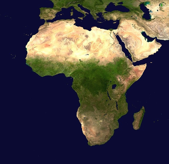
North Africa, specifically its location, is a region in the northern part of the African continent. It is bounded by the Mediterranean Sea to the north, the Atlantic Ocean to the west, and the Red Sea to the east. The Sahara Desert, the world’s largest hot desert, dominates much of the region. This article explores North Africa’s geography, countries, significant landforms, history, climate, and more, highlighting the importance of the North Africa location in understanding its unique characteristics.
Table of Contents
Key Takeaways
North Africa is geographically defined by the Mediterranean Sea, Atlantic Ocean, and the Sahara Desert, influencing its climate, ecosystems, and human settlements.
The region encompasses five countries: Morocco, Algeria, Tunisia, Libya, and Egypt, each with unique geographical features and cultural backgrounds shaped by historical civilizations.
North Africa faces significant environmental challenges, including water scarcity and desertification, necessitating sustainable management strategies to address these issues.
Geographic Boundaries of North Africa

North Africa is a region defined by its distinct geographic boundaries, which include the Mediterranean Sea to the north and the Atlantic Ocean to the west. The southern boundary is marked by the Sahel region, a transitional zone between the Sahara Desert and the more lush, tropical areas of Sub-Saharan Africa. This southern boundary is crucial as it delineates the arid landscapes of North Africa from the greener, more fertile lands to the south.
The Arabian Plate to the east defines the geological characteristics from Egypt to the Sudanese coast along the Red Sea, linking North Africa with the Middle East and creating a unique cultural and environmental blend.
Dominate by the world’s largest hot desert, the Sahara, covering over 75% of the region, North Africa’s climate, ecosystems, and human settlements are shaped by this harsh yet fascinating environment. Together, these geographic boundaries form a region that is both diverse and unified by its natural features.
Countries of North Africa

Five modern countries are located in North Africa. These countries are Morocco, Algeria, Tunisia, Libya, and Egypt. Each of these nations boasts distinct geographical features, from Morocco’s rugged Atlas Mountains to Egypt’s fertile Nile Valley. Morocco, located in the northwest, is known for its diverse landscapes, including coastal plains, mountain ranges, and desert regions. Algeria, the largest country in Africa, shares the Atlas Mountains with Morocco and is also home to vast stretches of the Sahara Desert.
Tunisia, situated in the northeast, benefits from a Mediterranean climate along its coast, making it a hub for agriculture and tourism. Libya, with its extensive desert terrain, relies heavily on its oil and gas reserves to support its economy. Egypt, located in the northeastern corner of the continent, is dominated by the Nile River, which provides essential water resources and fertile land for agriculture. The river’s presence has been a cornerstone of Egyptian civilization for thousands of years.
The Sahara Desert’s presence significantly impacts the climate and landscapes, directly influencing agricultural practices and settlement patterns in these countries. In Algeria, Libya, and Tunisia, the desert terrain poses challenges for farming, necessitating innovative irrigation techniques and water management strategies. Despite these challenges, North African nations have adapted to their environments and built thriving communities that reflect their unique geographical contexts.
Major Landforms in North Africa
The Nile River, a crucial geographical feature in North Africa, especially Egypt, creates a narrow, fertile valley vital for agriculture and sustains millions. Its importance as the lifeblood of Egyptian civilization spans millennia.
The Atlas Mountains, spanning northern Algeria, Morocco, and Tunisia, significantly influence the region’s climate and ecology. In Morocco, the High Atlas range features snow-capped peaks, offering a stark contrast to the surrounding arid landscapes and supporting diverse ecosystems. The Atlas Mountains supply essential water resources via rivers and streams that flow into the surrounding plains and deserts.
The Sahara Desert, the world’s largest hot desert, covers over 75% of North Africa. Its topography includes ergs (vast sand dunes), hammadas (rocky plateaus), and regs (gravel plains), each contributing to its unique landscape. The Sahara’s harsh conditions have shaped the cultures and lifestyles of the people who inhabit its fringes, making it a defining feature of the region.
Historical Overview
North Africa’s history is rich with ancient civilizations, conquests, and cultural transformations. One of the earliest examples of centralized civilization in the region is Egypt, which showcased advanced governance and culture following its unification. Carthage, established by the Phoenician princess Dido, became a major power in the Western Mediterranean before its defeat in the Punic Wars. The remnants of these ancient civilizations still influence the region’s cultural landscape today.
During Roman times, North Africa became a significant part of the Roman Empire, forming the Roman province of Africa from Carthaginian territories in 146 B.C.E. This period saw the construction of impressive infrastructure and cities that remain important archaeological sites. The early Muslim conquests in the 7th century introduced Islam to the region, rapidly spreading the faith and unifying various tribes under a common religious and cultural identity.
By the 8th century, much of North Africa fell under Muslim rule, leading to significant cultural changes through Arabization and Islamization, a result of the arab conquest. The emergence of Berber kingdoms, such as Numidia and Mauretania, responded to these invasions, significantly shaping the political and social landscape of the north african states.
The colonial era in the 19th century saw North Africa largely controlled by European powers, including France, the UK, Spain, and Italy. The post-independence era has been marked by political movements that led to the establishment of modern nation-states.
The historical narrative of North Africa is a complex one, encompassing key periods of:
Prehistory
Classic civilizations
The spread of Islam
Colonialism
All of these factors have led into the contemporary political landscape. The Ottoman Empire also greatly influenced North African cities like Algiers, Tunis, and Tripoli, shaping their culture and politics.
Climate and Ecosystems
Northern Africa predominantly experiences a hot and dry climate, with the northern regions influenced by Mediterranean conditions. This climate creates a stark contrast between the arid Sahara Desert, which covers about 94 percent of the land area, and the more temperate Mediterranean coast. The Mediterranean climate along the coast of Tunisia, for example, is essential for the cultivation of various crops, including olives and citrus fruits.
However, the region faces significant environmental challenges. Increased evaporation rates due to rising temperatures are reducing the available surface water, exacerbating water scarcity issues. Overextraction of groundwater is a significant concern, leading to the depletion of aquifers across North Africa. To address water shortages, coastal North African nations are increasingly relying on desalination, despite its high costs and environmental impacts.
Extreme weather events, including severe storms and flooding, are increasingly frequent, threatening water infrastructure. Sea level rise poses a long-term risk to coastal water infrastructure, including desalination and treatment plants.
Additionally, water quality issues are prevalent, with contamination leading to health risks, particularly in rural areas where people may rely on untreated water. These environmental challenges underscore the need for sustainable water management and climate resilience strategies in North Africa.
Economic Resources
North Africa is endowed with significant economic resources, particularly in the hydrocarbon sector. The region holds about 4% of the world’s oil and gas reserves, with Algeria, Libya, and Egypt notable for their rich deposits. These resources play a crucial role in the economies of these nations, driving revenue and development.
Phosphate mining, especially in Morocco, one of the world’s largest producers, is another vital economic activity in North Africa. This industry significantly contributes to Morocco’s export economy, providing essential materials for agriculture and other industries globally. The country’s phosphate mines are a cornerstone of its economic stability and growth.
Agriculture remains a fundamental part of North Africa’s economy, despite the arid conditions. The region produces a variety of agricultural products, including cereals, fruits, and vegetables, which are essential for both domestic consumption and export. Irrigation is vital for agriculture, especially around the Sahara Desert, where water is scarce and the climate harsh.
These economic resources highlight the region’s potential and the challenges it faces in balancing development with sustainability.
Cultural Landscape
North Africa’s cultural landscape is a rich mosaic of historical influences and diverse communities. Indigenous to North Africa, the Berbers have significantly contributed to the region’s history, developing kingdoms like Numidia and Mauretania. Their distinct languages and cultures, which predate the Arab migrations, reflect the deep-rooted heritage of the region.
Tribal affiliations and local identities among the Berbers vary significantly, illustrating their complex cultural and linguistic diversity. The presence of Berber dynasties, such as the Almoravids and Almohads, underscores the political significance of Berber culture in North African history. These dynasties not only shaped the political landscape but also influenced the region’s cultural and architectural heritage.
The introduction of Islam brought extensive changes, impacting social structures and fostering a new identity among Berber communities. The interactions between Berbers and Arab conquerors led to the gradual Arabization of the Berber population, influencing language and cultural practices. Historical trade routes facilitated cultural exchanges and interactions between different ethnic groups, further enriching the cultural landscape of North Africa.
Environmental Challenges
Environmental challenges in Northern Africa are significant and multifaceted. Desertification, driven by deforestation, overgrazing, and inadequate land management, threatens local ecosystems. This process disrupts the balance of these ecosystems, leading to reduced biodiversity and soil fertility. The impact of desertification is particularly severe in areas already facing arid conditions, exacerbating the challenges for agriculture and settlement.
Water scarcity is another pressing issue, affecting both agriculture and daily living conditions. The region is considered the most water-stressed area globally, with high demand and limited supply. Climate change intensifies these problems, increasing the severity of droughts and erratic weather patterns. These changes further strain the already scarce water resources, making sustainable water management a critical priority.
Efforts to combat these environmental challenges include initiatives to improve land management practices, promote sustainable agriculture, and enhance water conservation. However, addressing these issues requires coordinated efforts at local, national, and regional levels. North Africa’s environmental future hinges on adapting to and mitigating the impacts of climate change and resource depletion.
Learn more, checkout Africa faces disproportionate burden from climate change …
Political Landscape
North Africa’s political landscape is complex and dynamic, shaped by historical boundaries and contemporary challenges. Political boundaries demarcate the southern extent of North Africa, separating it from the Saharan regions. One of the most contentious political issues is the disputed territory of Western Sahara, which is administered by Morocco. This dispute complicates the political dynamics and has significant implications for regional stability.
Internal transformations and external pressures, especially after the 2011 Arab world protests, also shape the political landscape. These movements led to significant changes in governance and political structures in several North African countries. The involvement of new regional players like Russia and China, along with shifting roles of traditional allies, adds further complexity to the political environment.
North Africa’s political significance is increasingly recognized for its impact on regional trends across the broader Middle East and beyond. The region’s strategic location and resources make it a focal point for geopolitical interests, shaping its interactions with neighboring regions and global powers. Grasping the political landscape of North Africa is essential for understanding the broader dynamics of the Middle East and the African continent.
Archaeological Significance
North Africa’s rich archaeological significance, with remnants of ancient civilizations, offers glimpses into its history. The Pyramids of Giza in Egypt, built over 4,500 years ago, stand as monumental feats of engineering and remain one of the most iconic symbols of ancient Egypt. Constructed using around 2.3 million stone blocks, these pyramids highlight the advanced architectural knowledge and labor organization of the Old Kingdom era.
Founded by the Phoenician princess Dido in 814 BCE, Carthage rose to prominence as a major trading empire in the Western Mediterranean. Despite its destruction by Rome in 146 BCE, its archaeological remains, including harbors, walls, and residential areas, offer valuable insights into its strategic and economic importance. These ruins continue to be a testament to the city’s once formidable power and influence.
The site of Volubilis in Morocco, established as a key Roman outpost, features well-preserved ruins such as mosaics, thermal baths, and triumphal arches. Volubilis, an important administrative and agricultural center during the western roman empire, reflects Roman influence through its archaeological remains.
Similarly, the El Jem Amphitheatre in Tunisia, completed in 238 CE, is one of the largest and best-preserved Roman amphitheaters in the world, showcasing the architectural grandeur of ancient Rome.
Other significant archaeological sites include Leptis Magna in Libya, renowned for its stunning Roman ruins, and the Island of Meroë in Sudan, which features over 200 pyramids from the ancient Kingdom of Kush. These sites collectively highlight the diverse and rich archaeological heritage of North Africa, offering invaluable perspectives on the region’s historical development and cultural exchanges.
Transportation and Infrastructure
Transportation and infrastructure in North Africa have evolved significantly over the past century, transforming the region’s connectivity and economic potential. Since the 1950s, road development, supported by World Bank funding and national budgets, has been a key focus. These efforts have led to extensive road networks that facilitate the movement of people and goods across the region, enhancing trade and commerce.
The development of air transport since the late 1940s has also played a crucial role in North Africa’s modernization. Key international airports, such as those in Casablanca and Cairo, serve as major hubs for both passenger and cargo traffic, linking North Africa to the rest of the world. These airports are vital for international business, tourism, and cultural exchanges, contributing to the region’s economic growth.
While advancements in water transport have been minimal, the development of artificial ports along the North African coast has significantly improved maritime trade. These ports accommodate increasing volumes of international trade, enhancing logistical capabilities and economic opportunities. Together, these transportation and infrastructure developments have transformed North Africa, connecting its ancient past with a dynamic present and promising future.
Summary
North Africa is a region rich in history, culture, and natural wonders, defined by its geographic boundaries, diverse countries, and significant landforms. From the ancient civilizations of Egypt and Carthage to the modern nation-states of Morocco, Algeria, Tunisia, Libya, and Egypt, the region’s historical and cultural narratives are deeply intertwined with its environmental and economic contexts. The Sahara Desert, Nile River, and Atlas Mountains are monumental features that have shaped the lives and cultures of North African peoples.
Environmental challenges such as desertification, water scarcity, and climate change pose significant threats to the region, necessitating sustainable management and resilience strategies. Meanwhile, the political landscape continues to evolve, influenced by internal dynamics and external interests. The rich archaeological heritage and well-developed transportation infrastructure further underscore North Africa’s importance on the global stage. As we look to the future, it is clear that North Africa’s past and present offer invaluable lessons and opportunities for growth and collaboration.
Frequently Asked Questions
What are the main geographic boundaries of North Africa?
North Africa is primarily defined by the Mediterranean Sea to the north, the Atlantic Ocean to the west, the Arabian Plate to the east, and the Sahel region to the south. These geographic boundaries delineate the region’s distinct cultural and physical characteristics.
Which countries are considered part of North Africa?
North Africa is comprised of Morocco, Algeria, Tunisia, Libya, and Egypt. These nations collectively represent the region’s unique cultural and geographical identity.
What are some major landforms in North Africa?
The major landforms in North Africa include the Nile River, the Atlas Mountains, and the Sahara Desert, which significantly influence the region’s geography and ecology.
How has climate change affected North Africa?
Climate change has significantly intensified drought conditions and increased evaporation rates in North Africa, leading to heightened water scarcity and severe environmental challenges. These impacts underscore the urgent need for effective climate adaptation strategies in the region.
What are some significant archaeological sites in North Africa?
Significant archaeological sites in North Africa include the Pyramids of Giza, Carthage, Volubilis, El Jem Amphitheatre, Leptis Magna, and the Island of Meroë. Each site holds immense historical value and reflects the rich cultural heritage of the region.


